Firstly,i must introduce to you the national anthem of Malawi,my country before anything about this little paradise.Through these few verses i hope you have the picture of my motherland.The picture is better than that seen on CNN or BBC beacuse we have the strength to beat hunger,disease and envy.
watch tthis stunning video that gives you a bit of malawi
O God bless our land of Malawi
Keep it a land of peace
Put down each and every enemy
Hunger, disease, envy
Join together all our hearts as one
That we be free from fear
Bless our leader, each and every one
And Mother Malawi.
MAP OF MALAWI
The warm heart of Africa,an accolade that befits well for this land of the lake -Malawi,has its own unique history that this blog should notice so that i officially welcome you!
Malawis' population is of various tribes that migrated from other corners of Africa.We are now more than 12 million. Its gross national income (GNI) Malawi may rank among the poorest countries in Africa but we keep our smiles like we are living in heaven because this is our home, its economic backbone is Agriculture since indepence.
With changes of weather pattern,economic winds and the ant-smocking campaign looming tourism seems our only hope to turn into. The former British protectorate, Nyasaland became the independent nation of Malawi in 1964. In 1994,the first democratic elections were held .
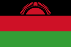
In 2004 Dr Bingu Wamutharika took over the mantle of reign from Dr Bakili Muluzi.The former among other things changed our national flag to echoe with the times of democracy and give it a voice
(as claimed by government bench in Parliament) that we have graduated from begginers to full Experienced nation.The rising sun was changed into full one,here under:

Official Name:
Republic of Malawi
short form: Malawi
former: British Central African Protectorate, Nyasaland Protectorate, Nyasaland.
ISO Country Code: mw
Local Time=UTC +2h
Country Calling Code: +265
Capital City: Lilongwe (pop. 600 000)
Other Cities:
Blantyre (the country's commercial capital), Zomba, Mzuzu
Government:
Type: multi-party democracy.
Independence: July 6, 1964.
Constitution: May 18, 1995.
Geography:
Location: Southeastern Africa
Area: 118,484 sq. km. (45,747 sq. mi.)
Terrain: Plateaus, highlands, and valleys. Lake Malawi (formerly referred to as Lake Nyasa) comprises about 20% of total area.
Climate: Predominately sub-tropical; two main seasons, cold-dry and hot-wet. The hot-wet season is from November to April.
People:
Nationality: Noun and adjective--Malawian(s)
Population: 10 million.
GNI per capita PPP: $ 596 (year)
Ethnic groups: Chewa, Nyanja, Tumbuka, Yao, Lomwe, Sena, Tonga, Ngoni, Ngonde, Asian, European.
Religions: Protestant 55%, Roman Catholic 20%, Muslim 20%, indigenous beliefs 3%, other 2%.
Languages: English (official), Chichewa (official), regional dialects, i.e., Chitumbuka, Chiyao, Chilomwe.
Literacy: total population 58%.
Natural resources: Limestone, uranium (potential), coal, bauxite, phosphates, graphite, granite, black granite, aquamarine, tourmaline, rubies, sapphires, rare earths.
Agriculture products: Tobacco, sugarcane, cotton, tea, corn, potatoes, cassava (tapioca), sorghum, pulses; groundnuts, Macadamia nuts; cattle, goats.
Industries: Tobacco, tea, sugar, sawmill products, cement, consumer goods.
Watch the video of our Lake Malawi
Imports partners: South Africa 53.7%, India 4.9%, Tanzania 3.9% (2003) Currency: Kwacha (MWK)
If you can be thrown in the jungle and you are asked about the direction you want to go to being Malawi then the above details are enough for now,however i am ready to offer more if you visit my page and ask questions.

